According to reports from Reuters and AFP on September 4th, the United Nations General Assembly voted to approve a resolution today in New York. The resolution encourages countries and organizations to reduce the use of the Mercator projection map, which has been in use for nearly five centuries, and switch to the 'Equal Earth' projection in 2018, which better reflects the true relative sizes of land areas.
The voting result was 164 votes in favor, 6 abstentions, and 1 vote against. The only opposing vote came from the United States. The resolution is not legally binding, and it does not prohibit the continued use of the Mercator projection in navigation and aviation.
According to reports, the proposal was initiated by Togo representatives of the African Group, supported by the African Union, and co-signed by France and other countries. The text indicates that the Mercator projection exaggerates the size of high-latitude regions and compresses the areas near the equator, resulting in a “persistent impact on cognition, education, culture, and geopolitics.” This leads to Africa and other regions being significantly reduced in public imagination.
"A fair world begins with a fair map." Said Robert Doe in an interview with Reuters. He said that distorted maps symbolically underestimate the size of African countries and create an imbalance in geographical views. The Gambia plans to switch its schools to use an equal earth projection within the country this year. France has stated they will give up the Mercator projection, replacing it with a map closer to actual area.
The Mercator projection was proposed by the Flanders cartographer Mercator in 1569. The constant lines are straight, which makes it convenient for navigation purposes. Therefore, it has long been the default map used in textbooks, media, and many digital maps. The downside is that the greater the latitude, the greater the area distortion: on common world maps, Greenland appears to be almost as large as Africa, while Africa’s actual area is about 14 times that of Greenland.
Equal Earth Projection was released in 2018. It is an equal-area projection, where Europe and North America appear relatively smaller on the map, while Africa and South America are more accurately represented in their true proportions.
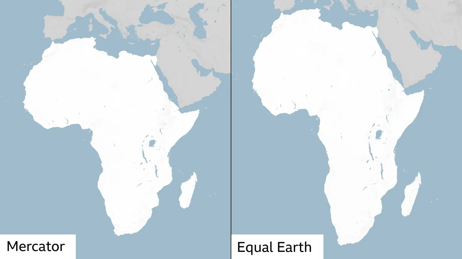
Mercator projection world maps are widely used, but they are not accurate. BBC
It is worth mentioning that no planar map can maintain both angle, area, and shape simultaneously. The resolution also acknowledges that different projections are suitable for different purposes.
The United States voted against it. U.S. representatives described the resolution as "redundant" and said it promoted an "ideological agenda," deviating from the peaceful, prosperous, and interstate relations that are important for the General Assembly. U.S. Ambassador to the United Nations, Mike Waltz, stated that this matter was not a harmless update of maps. Ukraine abstained, with its representative Andrey Melnyk saying that it was unable to support the text due to a "specific issue" related to equal earth projections.
The resolution clarifies that there is no challenge to Mercator’s applicability in maritime and aerial navigation. The Togo Ministry of Foreign Affairs also emphasizes this point.
The African Union has been promoting a campaign to 'correct maps' this year. The resolution calls on member states, international organizations, and educational, media, technological platforms to prioritize the use of equal-area projections when comparing countries and continents. School textbooks, official displays, and some online maps may be adjusted accordingly, but there is no obligation for countries, businesses, or navigation software to switch to new maps.
This is not a dispute over boundaries or sovereignty, but rather a debate about the public standards regarding how the Earth should be presented on a flat surface. Most countries choose to correct area distortions at the cognitive level, while the United States refuses to turn this into a United Nations political resolution.
Kenyan geographer Kioko Mundo believes that the Mercator projection maps actually underestimate the rich resources, population, and investment opportunities of the African continent. "Maps are not just guides for travelers—they also shape people's political and economic views about different regions," he told the BBC.