(Text by Observer Network, Liu Chenghui)
On September 29th, after being hit by heavy rain and floods for several days, the Thai capital Bangkok finally began to show signs of water receding.
Three days ago, this city with a population of over 8 million just experienced a rare moment:
On September 26, continuous heavy rain caused the water levels of several canals in Bangkok to rise dangerously high, and roads were flooded extensively. Mayor Datsak Sithiphan expanded the areas affected by the flood from three districts to the entire city.
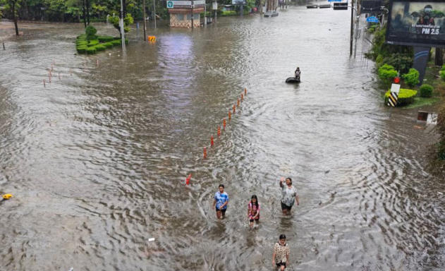
In some areas, the cumulative rainfall over 48 hours has reached nearly 300 millimeters. At the height of the flood, some vehicles on the roads had only the roofs exposed above the water level, and residents were forced to travel through water that was waist-deep. The Thai Disaster Mitigation Department also sent emergency alerts to residents in Bangkok, warning that the water levels in the city’s canals have reached dangerous levels and are continuing to rise.
After that, the low-pressure system that brought persistent heavy rainfall to Bangkok gradually moved westward, and the rainfall significantly weakened. The Thai government stated on the 29th that if no further heavy rainfall occurs, it will still take two to three days for the major waterlogged areas in Bangkok to be completely cleared. However, some low-lying communities remain submerged, and it will take even longer for them to fully recover.

September 29, 2026, Bangkok, Thailand - Floods wreaked havoc; people traveled through flood waters. IC Photo
According to estimates by the Thai Chamber of Commerce University, economic losses caused by the floods alone from September 25th to 29th could reach about 12.3 billion Thai bahts, with Bangkok accounting for approximately 7 billion Thai bahts. This does not include losses to property such as homes, cars, and agriculture.
But this flood is not the same as that “century flood” 15 years ago.
Thailand is facing not only the issue of how heavy the rain will be, but also the low-lying terrain in Bangkok, high water levels in the canals, water from the surrounding areas, and the entire drainage system being under pressure at the same time.
As of the morning of the 29th, there is still flooding in Bangkok and 29 other provinces in Thailand, affecting approximately 2.6 million people. Since September 16, the floods have affected 42 provinces and Bangkok, resulting in 23 deaths. The Bangkok Metropolitan Government estimates that about 700,000 people in the capital have been affected by this flood disaster.
Thousands of residents once flocked to temporary shelters. In the heavily affected Bongakpi district, floods even created temporary “water markets”. Reuters reporters observed that some vendors placed plastic boxes and buckets on the water surface, selling their goods outside their shops, while standing in knee-deep water to attract customers. A local resident said that the floods came too quickly, and there wasn’t enough time for them to prepare food for the household.
For many Thais, 2011 has almost become a measure of the severity of the floods.
That year, prolonged monsoon rains combined with several tropical cyclones led to massive floods in the northern and central regions. Floodwaters flowed southward along the Menam River system, inundating large areas of farmland, towns, and industrial parks. Eventually, the floodwaters approached Bangkok.
The World Bank's post-disaster assessment shows that the flood caused losses of approximately 1.43 trillion Thai bahts, which is equivalent to about 45.7 billion US dollars at that time. Important industries in Thailand, such as automobiles and electronics, were severely affected, and the global supply chain was also impacted.
After the disaster, how to avoid another "2011" has become a long-term issue for Thailand's water management efforts.
The Yingluck government subsequently introduced a comprehensive water resources management plan with a total cost of approximately 350 billion Thai baht. In addition to reservoirs and flood storage areas, an important concept is the construction of large-scale flood channels, allowing the water from the north to flow around Bangkok and the densely populated central areas, thereby allowing it to flow into the Gulf of Thailand more quickly.
However, this plan was not fully implemented. Some projects faced judicial reviews, environmental assessments, and local opposition. After changes in the Thai political situation in 2014, the original plans were adjusted again. Subsequent governments continued to introduce water management programs. However, some of the large-scale flood control ideas that were proposed in 2011 never really became reality.
Bangkok's own water management projects have been continuously progressing.
This city currently has a extensive drainage network, consisting of nearly 2,000 canals, over 200 pumping stations, several large underground drainage tunnels, and thousands of kilometers of drainage pipelines. After 2011, Bangkok continued to build new drainage tunnels, renovate pumping stations, dredge canals and pipes, and elevate some flood-prone roads.
These investments have not been in vain. The disaster management department noted during this flood season that some areas that were prone to waterlogging in the past were able to remain passable even when the canals were nearly full. New drainage tunnels, renovated pumping stations, and road construction projects have played a role. Of the more than 700 waterlogged areas identified in Bangkok, there are still more than 200 that require further improvement.
This year is also significantly different from 2011: there is much less water upstream.
Lanmar University's Director of Climate Change and Disaster Studies, Seree Supratid, explained that the current flow rate of water coming from the north through Nakhon Sawan is about 1800 cubic meters per second, while in 2011 it reached a peak of 4600 cubic meters per second.
Therefore, Thai experts such as Seree previously estimated that the likelihood of a large-scale flood disaster like in 2011 this year is very low.
Will Bangkok still be flooded?
Without the upstream floods that there were in 2011, where did all this water come from?

2011 Floods, Eastern Bangkok: People evacuate from the disaster area by wading through water. Visual China
The Thai newspaper 'National News' pointed out during this flood disaster that when Bangkok experienced more than 300 millimeters of rainfall, no significant amounts of water from upstream rivers entered the capital.
This time, what pushed the Bangkok drainage system to its limits was, first and foremost, the heavy rain that fell directly into the city.
During the peak of the flood, water accumulated on 93 roads in Bangkok, and the levels of several major canals reached dangerous levels. Pumping stations and drainage tunnels were operating at full capacity, with the overall drainage capacity reaching about 1200 cubic meters per second. However, water continued to rise rapidly in some areas.
Moreover, how quickly water is discharged depends not only on the size of the pumping stations and tunnels.
Nongbang water reservoir is an example.
This reservoir has a total capacity of approximately 5 million cubic meters. During the flood period, there is actually about 3 million cubic meters of space available for use. However, the canal connected to this reservoir has a very slow water delivery speed, resulting in a large amount of water accumulating and unable to be promptly transferred into the reservoir.
The Bangkok government has approved the construction of new drainage tunnels, which will directly connect the relevant canals with agricultural reservoirs.
This city also has poor drainage systems.
Bangkok is located in a low-lying area of the Chao Phraya River delta, with an average elevation of only about 1.5 meters. Some areas are also suffering from continuous land subsidence. As the city expands, a large amount of land that was originally capable of absorbing and temporarily storing rainwater is replaced by roads and buildings. As a result, heavy rain can only rely increasingly on canals, pipelines, pumping stations, and underground tunnels to be drained away.
This time, the high water levels in the Gulf of Thailand and the monsoon have slowed down the drainage process.
The survey indicates that Bangkok has previously simulated floods with 300 mm of rainfall, and the results showed that some areas might even experience water levels several meters deep. Although the actual situation did not reach the worst predicted by the model, this flood event provided an opportunity to test existing models and drainage systems.
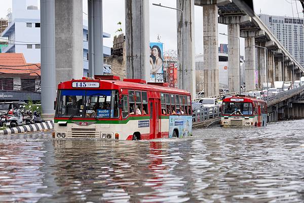
September 28th, Bangkok, Thailand: Bang Kapi District suffered severe flooding disasters. Visual China
Thai media and experts have frequently mentioned a term called "rain bomb" in recent days. Literally, it means "rain bomb".
This is not a strict meteorological classification, but rather a local term used to describe intense localized rainfall over a short period of time.
Thailand Agricultural University environmental scientist Thon Thamrongnawasawat pointed out that, under the backdrop of global warming, warmer ocean and atmospheric conditions may increase the risk of extreme rainfall. Even if floods like those that hit large areas of rivers in 2011 do not occur, severe localized rainfall can still quickly lead to urban flooding.
Thailand has been preparing for what could be the "next 2011" for over a decade, and this may not be the only flood that needs to be guarded against.
Seri believes that this torrential rain has exposed new challenges for Bangkok's flood control efforts. One of the key objectives of the drainage infrastructure built after 2011 was to cope with basin floods. Now, localized rainfall with extremely high intensity falling directly within the city is also becoming an increasingly real threat.
One of the methods proposed by the surveyors is to continue expanding the network of large underground drainage channels.
He described these facilities as “highways for water”: bypassing the city canals that are already near saturation and with slow drainage, these facilities help to transport the accumulated water into the Menam River more quickly.
Meanwhile, some large-scale flood mitigation proposals that had been dormant for many years have also been brought back into play due to this flood.
Thailand's Prime Minister Anuwinthai recently proposed a long-term water resource management project with an estimated cost of 250 billion Thai bahts. The plan aims to create new flood discharge channels for the Chao Phraya River. Some of these ideas can be traced back to water management plans after 2011.
Fifteen years ago, Thailand faced a century-long flood that spread along the Menam River towards the south. This time, more than 300 millimeters of rainfall fell on the roofs of Bangkok in just two days.
The forecasters said that no one can guarantee that such rainfall will not occur again next year, in ten years, or even later this year. What Bangkok needs to consider now is how to re-plan the city's drainage capacity in response to extreme rainfall amounts of 200 to 300 millimeters.